Is the Upper Delaware River ready for a Texas-like flood?
| August 4, 2025
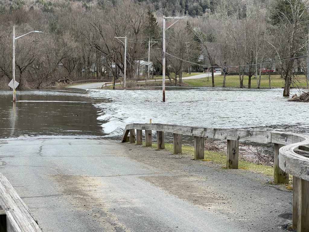
Molly Oliver knows of the flood risks lurking in the twisty-turny valleys of the Delaware River’s headwaters near the New York-Pennsylvania border. And she suspects that warning systems meant to alert nearby residents of impending danger have gaps.
But she also wonders what, if anything, can be done to offer complete peace of mind in an era of supercharged, super-local extreme rainfalls, the likes of which have recently clobbered communities in North Carolina, Kentucky and Central Texas.
“It’s so much more complicated than just hitting the big red button when it’s going to flood, and then people get out of there,” said Oliver, executive director of the nonprofit Friends of the Upper Delaware River.
First, there’s the geography: hilly terrain that holds scores of streams and creeks in the Delaware’s headwaters, each one capable of bearing a flash flood in severe weather. Then, there’s technology: spotty cell service in such areas leaving doubt about whether warnings would reach people in time. Finally, of course, there’s the human element.
“If the alarm goes off a few times and your house is fine every time, then you’re like, ‘I don’t have to leave when the alarm goes off,’” Oliver said.
Oliver isn’t professionally trained in flood warning systems, but turns out she’s onto something.
Accounting for the human element
Abdul-Akeem Sadiq, an expert in emergency and crisis management at the University of Central Florida, said that when it comes to warning people about floods, the availability of technology and knowhow aren’t often what’s missing. For example, he notes, the Sunshine State is well-acquainted with stormy weather, but that also means its emergency response infrastructure is finely tuned and well-maintained.
Problems instead often arise from a human element in geographies where potentially catastrophic events are rarer, and thus political and financial resources are often focused elsewhere. “You come down to the money, right?” Sadiq said.
News reports on the recent tragedies in Central Texas, where more than 130 people were killed by flooding following an extreme rainstorm, appear to reveal such dynamics at play. Over the past decade, officials in Kerr County, Texas, considered adding devices to monitor water levels and physical sirens along the Guadalupe River, The New York Times reported. But after failing to secure a $1 million federal grant, political leaders appeared to balk out of concern that voters in the rural, conservative county didn’t want to foot the bill.
“I think this whole thing is a little extravagant for Kerr County, with sirens and such,” H.A. Baldwin, a former county commissioner, said as he voted against paying $50,000 for an engineering study in 2016, according to The Kerrville Daily Times.
There are some eerie analogues in the Upper Delaware Valley.
Take, for instance, a largely unknown 2019 effort by U.S. Senator Chuck Schumer, D-N.Y., to shake loose $150,000 in federal grant money to install an audible warning system in Delaware County, N.Y., particularly in the vicinity of major reservoirs there, as well as in the western part of the county, where cell service is lacking. The money, Schumer wrote in a letter to the Appalachian Regional Commission, would help pay for a $330,000 plan by Delaware County officials “for the installation and management” of a new emergency notification system.
“Even though Delaware County maintains a unique risk and painful history of flash and major flooding, and the Delaware River Basin has a bustling tourism industry that must be protected from harm, the area is lacking an effective audible warning system for imminent flooding,” Schumer wrote.
Neither Schumer’s office nor Delaware County officials responded to questions from Delaware Currents asking whether grant money was ever obtained or a system ever installed.
The Appalachian Regional Commission’s website notes a $150,000 award in 2023 for a “Delaware County Strategic Action Plan,” but a related request for proposals from Delaware County suggests the plan is primarily for economic development, not emergency alert systems.
Oliver adds that to her knowledge, no physical alert systems have been installed near the Cannonsville Reservoir or elsewhere in the upper watershed’s western edges.
Weather self-defense: How to get real-time alerts to help you prepare
Sounding the alarm about the lack of sirens
Similarly, the nonprofit Upper Delaware Council in the 2010s supported a physical flood alert system consisting of existing emergency sirens, such as those operated by firehouses, in the upper watershed.
In 2016, the group launched an effort to pressure the New York City Department of Environmental Protection, which owns and operates three reservoirs and dams in the Upper Delaware watershed, to provide better emergency communications planning.
“The Council seeks a serious exploration of viable methods to help mitigate the loss to lives, property, and infrastructure that might result from any dam failures or catastrophic weather events that could inundate downstream communities in a matter of precious minutes or hours,” the organization wrote in a public letter.
Specifically, the council proposed repurposing existing sirens to perform flood warnings using a specific frequency, so as to warn residents in areas without cell service. But follow-up records provided by UDC show the effort proved in vain. While some local officials supported the idea, responses from NYCDEP cited misgivings about repurposing sirens from several industry experts.
The NYCDEP did not respond to Delaware Currents request for information for this story. However, past correspondence between UDC and emergency personnel in half a dozen counties and towns also generally revealed concerns about the limited number of sirens, their age and how far their sound would carry.
“They are very old technology, and the decibel level that they have is such that it only carries for a very small distance… programming them to set off a certain tone may prove to be very difficult as well, if not impossible,” Stephen Hood, the emergency management director for Delaware County, told the UDC in 2016.
Forging a new approach
Laurie Ramie, the executive director of the UDC, said the group has since shifted its focus to the ongoing development of a “Delaware River Inland Emergency Response Plan,” which she describes as a developing but promising coordination among federal agencies, such as the National Park Service and Environmental Protection Agency, as well as states and counties in the Upper Delaware watershed.
The need for such an effort was made clear by a 2023 train derailment in Deposit, N.Y., which spilled 4,000 gallons of oil into the watershed and, Ramie said, revealed a disjointed emergency response system in which some officials were learning updates from the news media instead of government partners.
Recent meetings and tabletop exercises for the initiative have included conversations about how best to reach the public in the event of an emergency like a flash flood, Ramie said.
“In areas with spotty cell service, you can’t count on an instant alert system,” Ramie said. “You have to get creative.”
Seeking solutions after multiple years of floods
In April 2005, a perfect storm of heavy rainfall and melting snow led to dramatic flooding along the Delaware River, and Jenn Canfield’s horses were in harm’s way. Her family has operated the Diamond C Horse Farm, where they rear horses, along the edge of the Delaware in Wayne County, Pa., for more than half a century.
Half of the property is in a federal floodplain, but Canfield said she never saw the waters rising like she did in 2005, and had not received any warning from the authorities. Fortunately, Canfield said, it was daylight and she and neighbors were able to ride the horses to higher ground before their pastures were overtaken. A historic barn and farmhouse on the property were ultimately spared damage.
Still, the flooding left a psychic scar. As extreme rainfall has seemingly become a new normal in recent years, Canfield grew worried about the lack of a physical alert system along the river, which she believes could signal to nearby homeowners when it’s time to get out. She approached leaders of her local community, Damascus Township, but feels that her entreaties were not taken seriously.
After witnessing the recent flooding in Texas, her concern is as high as it’s ever been.
“I looked at it as, you know, ‘See? Look at what can happen if you don’t have a siren,’” Canfield said.
The 2005 flooding, along with similarly damaging events the year before and after, did result in the most comprehensive study of flood risks in the Delaware River in recent history. After the floods wreaked havoc throughout most of the watershed, the interstate Delaware River Basin Commission pulled together a large suite of local, state, and federal partners to study and plan for the threat.
In 2007,the DRBC released a comprehensive report that ended with 45 specific recommendations, 14 of which dealt with flood warning systems. Commission records show some follow-up in the years after, although its Flood Advisory Committee is now currently listed as inactive and appears to have last met in 2016.

So how many of those 14 recommendations — which range from inventorying existing equipment like gauges, hardening infrastructure against floodwaters, improving modeling and forecasting, and establishing a “coordinated flood warning education and outreach program” — were ever accomplished?
The DRBC didn’t specify in an email, but Kate Schmidt, a spokeswoman for the commission, wrote that “approximately 30” of a larger suite of 45 recommendations from the report have been implemented. She also indicated the commission eventually stopped keeping track, but instead shifted its focus to other flood mitigation efforts as states began taking on more responsibility for certain tasks.
“DRBC strives to coordinate, rather than duplicate, efforts of its members and partners,” Schmidt said, providing an example of states overseeing emergency plans for dams, a task originally ascribed to the commission in its 2007 report.
For this story, Delaware Currents also contacted more than dozen entities, from federal agencies like the National Weather Service to emergency management personnel on both sides of the New York-Pennsylvania border. Most did not respond. However, the National Weather Service, listed as the lead agency for five of the original 14 flood warning recommendations, said it has made progress.
Jim Brewster, senior service hydrologist with the Binghamton, N.Y. office of the Weather Service, said the agency has evaluated its river forecast points and techniques as a part of routine processes. There are also ongoing national efforts to develop inundation maps (projected to be 60 percent complete by September and 100 percent by the end of next fiscal year) and improve flash flood forecasting, for which Brewster said new or experimental tools are available to forecasters.
He added he was unfamiliar with a plan for a fifth recommendation — to develop a site-specific model for the area — but that his office has used applicable software for “over two decades.”
The USGS, lead agency on four other recommendations, including the inventorying and hardening of gauges, did not respond to inquiries. However, the DRBC’s Schmidt said the service indeed “flood-hardened, raised and reinforced streamflow gages above historic flood levels to prevent outages during future high-water events.”
Northampton County, Pa., a middle-watershed community with a history of flooding along the Delaware and Lehigh Rivers, said it believes significant improvements have been realized since the 2007 DRBC study.
Jessica Berger, the county’s public information officer, said that real-time stream and river gauges have been installed in waterways there to improve data collection, and that the county has upped its coordination efforts with groups like the Pennsylvania Emergency Management Agency and DRBC, although she added that the county has been unable to get a “seat at the table” for DRBC’s committee meetings.
Schmidt said the commission has “facilitated funding” for work by the USGS and Weather Service to upgrade steam gage infrastructure, create flood inundation maps, and add forecast locations, efforts that date back to the late 2000s.
“However, models are not perfect,” Schmidt said, adding that it is important for facilities like hospitals, schools, and campgrounds in flood-prone areas to “register with appropriate state and local emergency management agencies and check weather forecasts for flood watches, warnings and advisories frequently, especially when heavy precipitation is predicted.”
The New Jersey Department of Environmental Protection provides an example of such coordination.
The state operates a large campground along the river’s edge just north of the Delaware Water Gap. Caryn Shinske, a spokesperson for NJDEP, said the state monitors a local river gauge at Tocks Island and, in coordination with the NPS, closes recreational access to the river when its waters reach16 feet, five feet below the 21-foot flood stage for the area. Lower campsites at the river are not affected until 24 feet, and upper campsites 28 feet, she said.
She said Worthington State Forest last experienced flooding in 2006, when the river crested at 33.87 feet. “Water entered buildings, and campgrounds were safely evacuated,” Shinske added.
Sadiq, the flooding expert, said there is never a time when the job for planning for floods is done. Best practices call for emergency management plans to be updated at least every two years, to rope in fast-changing conditions, such as new media platforms, climatic conditions, changing demographics, and growing development. Maintenance is often where plans start to unravel, he said, as communities lose motivation to bear the cost of planning, repairing, and testing alert systems as a natural disaster recedes into the rearview mirror.
And in the end, Sadiq added, there’s also no way around providing some form of physical alert system in areas with unreliable cell coverage, whether that be sirens or somebody “grabbing a bullhorn and going down a street” to warn residents. And across the Upper Delaware River watershed, it still seems that none are in place.
“Any alert or warning system must combine old and new technology,” Sadiq said.
“We cannot rely on only one of them.”


![DC_Image [Image 4_Assunpink Meets Delaware] meets Delaware The Assunpink Creek on its its way to meet the Delaware River. The creek passes through woods, industrial and commercial areas and spots both sparkling and filled with litter.](https://delawarecurrents.org/wp-content/uploads/bb-plugin/cache/DC_Image-4_Assunpink-meets-Delaware-1024x768-landscape-14f069364113da5e8c145e04c9f2367c-.jpg)


“Neither Schumer’s office nor Delaware County officials responded to questions from Delaware Currents asking whether grant money was ever obtained or a system ever installed.”
“…no response.”
This would be typical. Sen. Schumer, followed by Gillibrand, have made it their purpose to back the NYCDEP in everything it does–including exacerbate flood crests below its reservoirs. Advocates for flood victims have been banging on their (and several other) doors for years. Stonewall. If another terrible flood hits the Delaware and Hudson River Basins all of these “responsible” entities will take their phones off the hook.
The DRBC is a useless puppet:
“Commission records show some follow-up in the years after, although its Flood Advisory Committee is now currently listed as inactive and appears to have last met in 2016”.
So much for the folks still waiting downstream.