Underwater exploration of Upper Delaware yields hidden history
| December 9, 2024
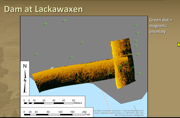
An underwater exploration of the Upper Delaware Scenic and Recreational River revealed at least two sunken relics from bygone days: the 19th century remnants of a dam and bridge footings.
The findings are not exactly pirate’s booty or of legendary shipwrecks carrying gold bullion but they do spotlight pieces of history under the water’s surface in the Upper Delaware and were a good demonstration of the technology used to find them.
The findings were presented at an Upper Delaware Council meeting on Thursday night by David W. Morgan and Matt Hanks, archeologists for the National Park Service.
Small NPS dive team
Morgan and Hanks are part of a small Park Service team at the Submerged Resources Center, which specializes in underwater exploration. Among other duties, the team inventories cultural and archeological resources, performs maintenance work, installs scientific equipment and engages in search-and-recovery missions.
The public is often surprised to learn how much land the Park Service manages under water: some 3.5 million to 5 million acres, Morgan said.
The National Park Service was the first nonmilitary agency to use scuba as a management tool, starting in 1959, though the current seven-person team formally traces its origins to 1980.
The group trains to dive in a variety of conditions and settings, like deep and cold, shallow, tropical, low-visibility or enclosed spaces in multiple Park Service units and parks.
Remote sensing
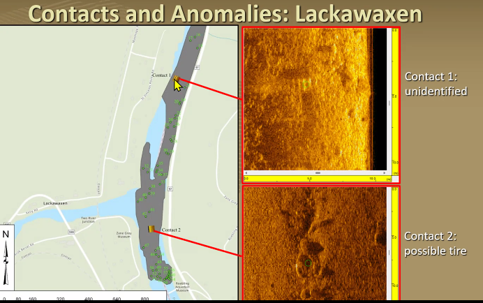
As part of their survey of the Upper Delaware Scenic and Recreational River, the team relied on a magnetometer and side-scan sonar to identify anomalies below the water line and to alert them to Ferris, manmade objects. A so-called tow fish, part of the side-scan sonar, is dragged behind a boat to get almost photo-quality images of what lies beneath.
In its visit in September, the team covered 5.7 linear river miles, or 300 acres, with the sonar and 3.6 miles, or 101 acres, with the magnetometer.
Morgan allowed as how the findings of two major archeology sites — remnants of a 19th century dam and footings of 19th century bridge from a crossing near Damascus, Pa. — might be known to the assembled UDC members who would be well familiar with the history and terrain of the upper river. He even joked that their presentation might be like “bringing coal to Newcastle.”
Findings of interest
Still, UDC members were appreciative and interested in the findings, which included underwater images of 37 submerged pieces of vegetation-coated timber that appeared to be a remnant of a dam that was built as part of canal system to transport coal in the 1800s. Their research also revealed what they said were probably footings from three different eras of transportation at Damascus, from 19th, mid-20th and contemporary bridges.
Despite the fairly clear findings, some mysteries persist. The team recorded 21 sonar and 129 magnetic anomalies that were difficult to identify. Some of them could be a discarded tire or other trash, or some could be historic artifacts, Morgan said.
The exploration provided practical lessons about using the technology as well. Morgan said they learned that sonar is terrible in really shallow water, it’s best to visit in highest water as possible and during the off season in order to stay out of way of recreational river users.


![DC_Image [Image 4_Assunpink Meets Delaware] meets Delaware The Assunpink Creek on its its way to meet the Delaware River. The creek passes through woods, industrial and commercial areas and spots both sparkling and filled with litter.](https://delawarecurrents.org/wp-content/uploads/bb-plugin/cache/DC_Image-4_Assunpink-meets-Delaware-1024x768-landscape-14f069364113da5e8c145e04c9f2367c-.jpg)
