
New map reveals contours of the deepest part of the Delaware River in Narrowsburg, N.Y.
| June 5, 2024
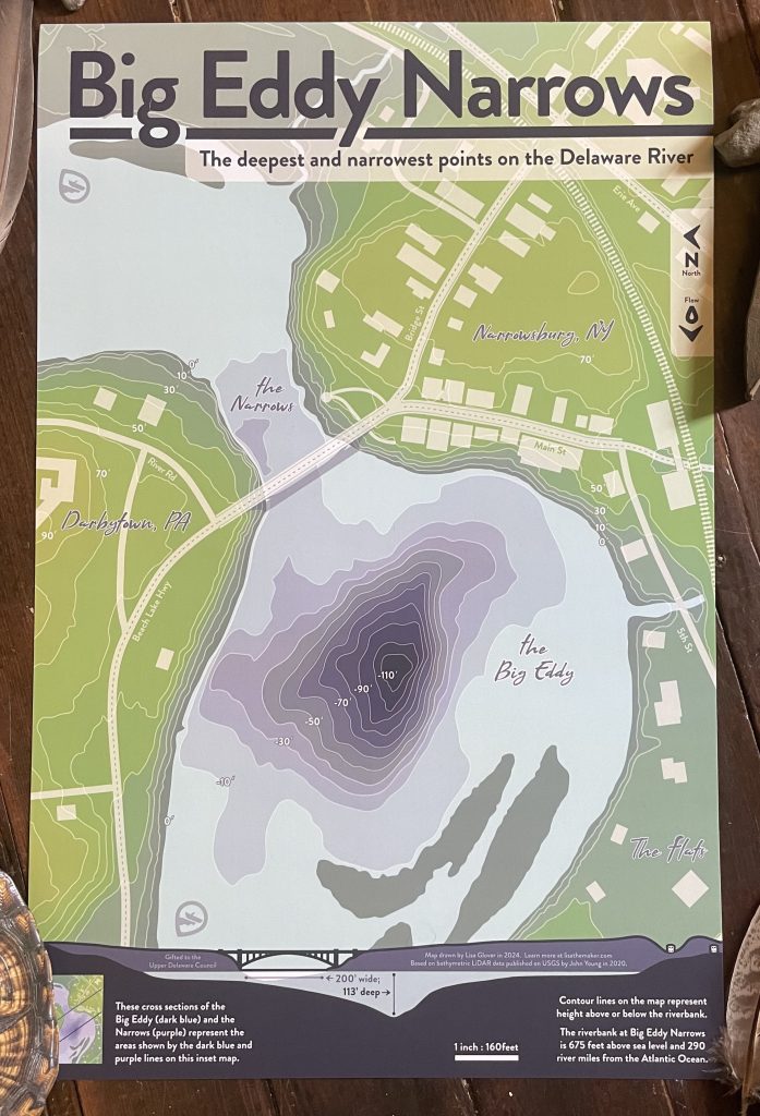
When Lisa Glover visited the Delaware River in Narrowsburg, N.Y., she was at the deepest and narrowest point of the 330-mile river.
But at first glance, she didn’t know just how deep and narrow it really was.
She stood in front of an informational kiosk at a site known as the Big Eddy Narrows, where she was puzzled about the diagram, which lacked indicators as to scale.
Where she was, at River Mile 290 in Narrowsburg, a hamlet in the Town of Tusten, the Big Eddy runs 113 feet deep and has a section only 200 feet wide.
But the map did a poor job of reflecting that, with confusing cross-sections that misrepresented the river.

The issue stemmed from the diagram being pulled from a 1990 Upper Delaware Council newsletter that forgot to mention the image was compressed 10 times, ruining its accuracy.
And with little to no cell service in the rural area, it’s hard to pull up any more information on the deepest part of the river.
“I like to joke that a good amount of my creativity comes from being annoyed about something and needing to fix it,” said Glover, 33, who lives in Honesdale, Pa. “I had to figure out what was going on here because this is a hugely important feature of our river. It seemed odd to me that the only visual that was out there in the public eye was one that didn’t have any context around it and actually might give people a very different impression from what’s actually going on.”
Getting to work
That’s when Glover headed to the UDC headquarters to gather any insights on what was going on with the diagram and if anyone previously made a topobathymetric map of the area.
The answer was no.
Topographic maps show the elevation of landforms above sea level. Bathymetric maps show depths of landforms below sea level. Her map combined the two — land elevation and water depths — for a fuller picture.
Glover’s partner worked as the cartographer for Wayne County in Pennsylvania for years. With that background, blended with her love for the outdoors and water specifically, Glover set out to make a better map.
“Even from a safety perspective, it seemed like a really important thing to understand how deep this is and where,” she said.
Making the map would be feasible to do, especially after getting in touch with older stakeholders, like John Young, a research scientist at the U.S. Geological Survey, who had a LiDAR image of the area.
She went for it.
“Taking the LiDAR image and turning it into something more people can understand is something that was well within my wheelhouse,” Glover said. “I enjoy making sure that more people have an understanding of complex topics like underwater topography.”
LiDAR, or Light Detection and Ranging, is an active remote sensing system in the form of a pulsed laser that can be used to measure across wide areas.
She said that for her, this was a chance to do work similar to what she does for the Center of Rural Innovation but instead to make a difference in her own community.
The center, which is in Hartland, Vt., has employees in rural areas across the country and works to advance rural economies and close the rural opportunity gap.
“I felt like creating this illustration was a chance to help local people grow in their understanding of this incredible natural feature that we’re so lucky to have up here, and that often doesn’t get the kind of recognition that it deserves,” she said. “That’s what inspired me.”
Poster of map available to public
The topobathymetric color map shows 10-foot contour lines and to-scale cross sections of the site.
Will the kiosk be replaced with Glover’s new map? Probably not in the near future, but Glover says that even putting a sticker over the original image to inform people that it’s not accurate would be helpful.
For now, those interested in the map can pick up a poster at the UDC. She offered a stack to the UDC to share with the public as a fundraiser.
To request a Big Eddy Narrows poster for a $20 donation to the UDC, contact Stephanie Driscoll at stephanie@upperdelawarecouncil.org, 845-252-3022, or stop by the UDC’s office at 211 Bridge St. in Narrowsburg. Supplies are limited.


Recent Stories


